
Cargando...
Trova
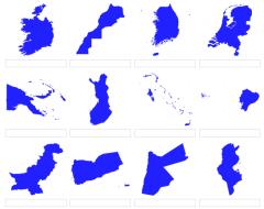
Bases on the following shapes, can you tell the name of the countries which represents?
It is an educational content by JetPunk, site that contains a wide variety of quizzes.
Excluding very small countries, which countries have the greatest percentage of forest cover?
It is an educational content by JetPunk, site that contains a wide variety of quizzes.
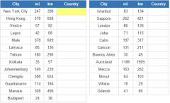
For every city below, name the closest country to them, excluding the country its in.
It is an educational content by JetPunk, site that contains a wide variety of quizzes.
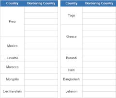
Given a country, list the countries that border it.
It is an educational content by JetPunk, site that contains a wide variety of quizzes.
Which countries are closest to China?
It is an educational content by JetPunk, site that contains a wide variety of quizzes.
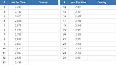
Based on mm per year, name the 25 countries with the most rainfall or precipitation.
It is an educational content by JetPunk, site that contains a wide variety of quizzes.
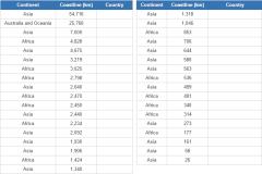
Name all the countries that border the Indian ocean.
It is an educational content by JetPunk, site that contains a wide variety of quizzes.
Guess the biggest cities in Mexico according to the 2010 census. Enter an answer into each box.Wait for Geography Questions #4! It will come out in about 1-2 days.Quiz by Jhangeomath (subscribe ...
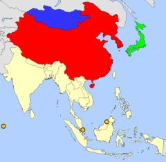
Fill in the map of East Asia by correctly guessing each highlighted country.
It is an educational content by JetPunk, site that contains a wide variety of quizzes.

Name the country which has the closest area to the US state. To make it easier, you have given the first letter of the country.
It is an educational content by JetPunk, site that contains a wide variet ...

The Tropic of Cancer is a line of latitude about 23 degrees north of the equator, and is one of the five major lines of latitude, along with the Equator, Arctic and Antarctic circles and Tropic of Cap ...
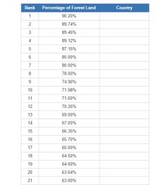
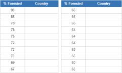
Name the countries by the percentage of their land that is forest.
It is an educational content by JetPunk, site that contains a wide variety of quizzes.
Aggiungere a Didactalia Arrastra el botón a la barra de marcadores del navegador y comparte tus contenidos preferidos. Más info...


