
Cargando...
Atopa
visualización
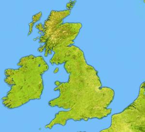
Try to locate on the map each given sea and island of the United Kingdom and Ireland.
Given the location, name the largest island nations in size.
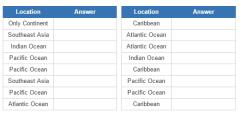
It is an educational content by JetPunk, site that contains a wide variety of quizzes.
How many islands can you think of that are divided between at least two countries? And which countries are those?
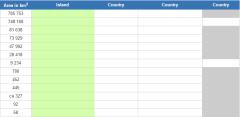
It is an educational content by JetPunk, site that contains a wide variety of quizzes.
Engadir a Didactalia Arrastra el botón a la barra de marcadores del navegador y comparte tus contenidos preferidos. Más info...


