
Cargando...
5092 mapasInteractivos
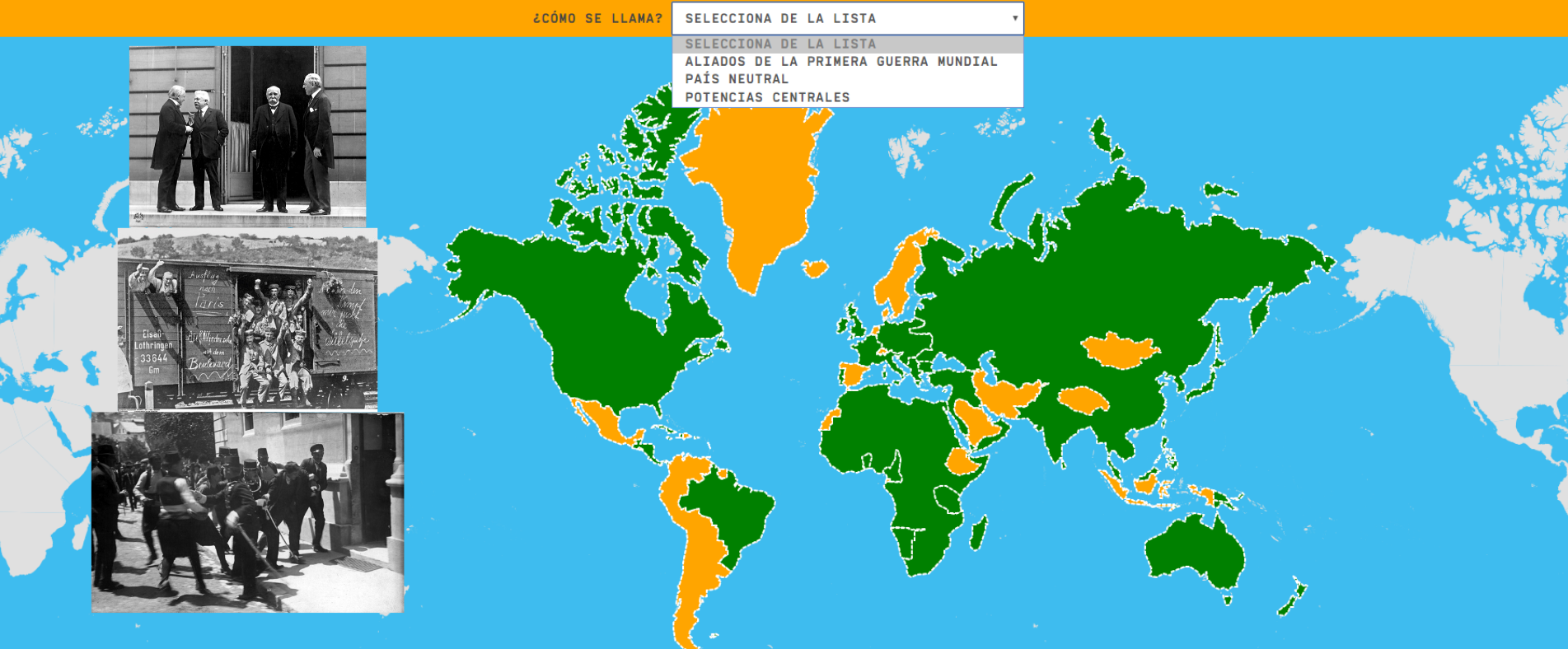
textoFiltroFichatipo de documento Interactive map. What is its name?
About this resource...
Learn with this interactive game the different positions of the countries with respect to the First World War. Although in this game it has been limited to the classification in three groups (allies, central powers and neutral countries), we could really talk about:
Similarly, it should be noted that some countries changed sides during the contest. In addition, some of these countries no longer exist today and others have modified their borders.
Oceanía
África
Asia
Europa
América del norte
Sudamérica
Fichero GeoSon Download file
Latitud centro mapa 29.244
Longitud centro mapa -33.308
Zoom 3
Tipo de mapa Político
Autores:
Categories:
Shared with:
")
Add to Didactalia Arrastra el botón a la barra de marcadores del navegador y comparte tus contenidos preferidos. Más info...
Didactalia provides you with a collection of 200 maps to play. Interactive maps with game mechanics to learn geography while having fun.
Each game has a maximum score you can reach if you answer correctly every question on the first attempt. Your points will be kept if you answer all questions and if you are logged in the community. The points won't be added to your score if you leave the game site before finishing the game or if you are not registered in. If you haven't joined us yet, you can register in here.
In the "Ranking section" of every map you can see the ranking of the best players, but you can also see your position and that of players with a similar score. The ranking is marked by the score you obtained (depending on number of correct answers and mistakes) as well as the time it took you to end the game. In the "Statistics section" of the maps you can check the results of your last, and best game.
Your position in the global ranking depends on the sum of the points you obtain in all maps you have played, plus/minus the "bonus points" of the challenges you win/lose.
The challenges give you the chance to face the player you choose. You will be able to challenge players in the maps you have played at least once, but remember it will be the score of the last game you played in that map the one that your rivals will have to surpass. You can pick your opponent among the players that appear in the ranking of the map. Similarly, every time you finish a game you will have the option to challenge other players. Once you challenge someone, we will send a message to the other player with your score and a link to the game you have challenged him/her, and we will invite that player to surpass your score.
The scoring system that it is used in Didactalia's challenges is based on ELO rating system which it is used in games like chess. This method is useful to calculate the relative skill levels of the players that compete against each other: - The player with more points, i.e. better global position, will lose more points if he/she loose, and he/she will obtain less points even if he/she wins. - The player with fewer points, therefore a worst global position, will lose less points if he/she losses, but he/she will obtain more points if he/she wins.
They are the points you win or lose when you accept a challenge. These points will be added or substracted from your total scoring. For instance, if you obtain 140 points in a challenge game that has a bonus of +100/-20, you will obtain 240 points if you win, but only 120 if you lose.


Compartir en: