
Cargando...
5092 mapasInteractivos
textoFiltroFichatipo de documento Download Anfahrtskarte
Über diese Ressource...
Mapa para imprimir de Europa y Asia Central
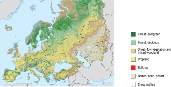
Un mapa en color para imprimir con el relieve de Europa y Asia Central. La parte occidental del continente euroasiático, tiene algunas de las zonas más pobladas y fértiles del mundo. Europa central está densamente poblada. En el norte - Escandinavia y el norte de Rusia, tenemos la taiga, con grandes extensiones de bosques, y más al norte, están la tundra y los glaciares. Asia Central y el Cáucaso es una región diversa, con desiertos, montañas, agricultura y pastizales.
Es un contenido publicado en www.grida.no
Geographical Information
“The Western part of the Eurasian continent, has some of the most populated and fertile parts of the World. Central Europe is densely populated, with few remaining fragments of undisturbed habitat, except for the mountain ranges. In the north - Scandinavia and Northern Russia, there is the taiga belt, with vast expanses of confierous forest, and further north, there is tundra and glaciers. Central Asia and Caucasus is a diverse region, with deserts, mountains, agriculture and grasslands.”
This is a content published at www.grida.no
Asia
Europa
Autores:
Kategorien:
Geteilt mit:
Add to Didactalia Arrastra el botón a la barra de marcadores del navegador y comparte tus contenidos preferidos. Más info...

")


Compartir en: