5092 mapasInteractivos

textoFiltroFicha
  • Gefällt mir 0
  • Besuche/Aufrufe 416
  • Kommentare 0
  • Aktionen

Über diese Ressource...

Imágenes

Características

Descripción:

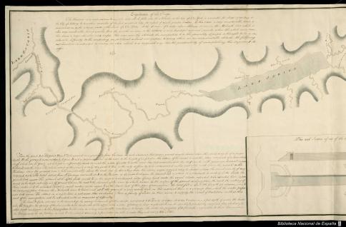
A Desing for improving the Navigation of the Mohawk River whit a view of opening an Inland Navigation to the Great Lakes by Christopher Colles Engineer 23 December 1785

Notas:

Manuscrito sobre papel a plumilla y lavado en gris

Tamaño: 1 mapa
Idioma/Lengua: English
Autor

Autores secundarios:

Nombre del autor secundario: Colles, Christopher

Link Sitio Web

Publicación

Fecha de publicación: 1785
Lugar:
Mohawk
Estados Unidos

Información geográfica

Continente
América del norte
Pais
Estados Unidos

Kategorien:

Fecha publicación: 14.8.2013

Únete a Didactalia

Browse among 5092 resources and 595705 people

Regístrate >

O conéctate a través de:

Si ya eres usuario, Inicia sesión

ESRI

Möchten Sie auf weitere Bildungsinhalte zugreifen?

Einloggen Tritt einer Klasse bei
x

Add to Didactalia Arrastra el botón a la barra de marcadores del navegador y comparte tus contenidos preferidos. Más info...

Spielhilfe
Juegos de anatomía
Selecciona nivel educativo