
Cargando...
Atopa
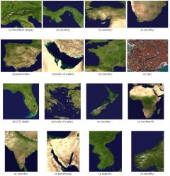
Based on the satellite images, can you guess the countries or territories they represent?
It is an educational content by JetPunk, site that contains a wide variety of quizzes.
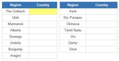
For each selected region, name the country in which it is located. Answer must correspond to highlighted box.
It is an educational content by JetPunk, site that contains a wide variety of quizzes.
Engadir a Didactalia Arrastra el botón a la barra de marcadores del navegador y comparte tus contenidos preferidos. Más info...


