
Cargando...
Trouvez
visualisation
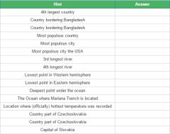
You give a city, then tell the five countries that are closest to it, excluding the country it is actually in.
It is an educational content by JetPunk, site that contains a wide variety of quizzes.
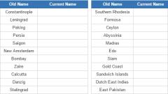
Based on the old name, guess the modern name for each of these places.
It is an educational content by JetPunk, site that contains a wide variety of quizzes.
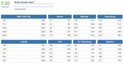
Guess the biggest cities in Mexico according to the 2010 census. Enter an answer into each box.Wait for Geography Questions #4! It will come out in about 1-2 days.Quiz by Jhangeomath (subscribe ...
Ajouter à Didactalia Arrastra el botón a la barra de marcadores del navegador y comparte tus contenidos preferidos. Más info...


