
Cargando...
Find
Do you know what is the name of each landform shown on the map? You have to choose the right answer from a list with several possible options.
Zoom in or zoom out the map in order to adjust it to the s ...
Do you know what is the name of each landform shown on the map? You have to choose the right answer from a list with several possible options.
Zoom in or zoom out the map in order to adjust it to the s ...
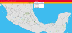
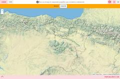
Choose from the proposed list the name of each of the mountains of Mexico indicated on the map.
Zoom in or out of the map and adjust its size to the screen of your device. You can also click on the map ...
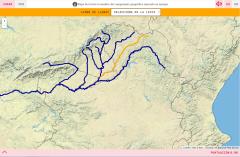
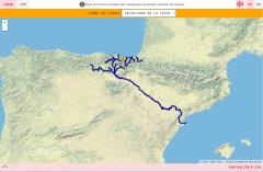
Do you know what is the name of each river of the Autonomous Region of Madrid shown on the map? Test yourself with this interactive map, you have to choose the right answer from a list of several opti ...
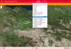
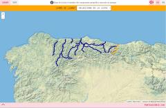
Do you know what is the name of each river of the Basque Country shown on the map? Test yourself with this interactive map, you have to choose the right answer from a list of several options.
Zoom in o ...
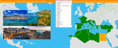
Learn with this interactive game the countries bathed by the Mediterranean Sea.
Zoom in or out of the map and adjust its size to the screen of your device. You can also click on the map and drag it to ...
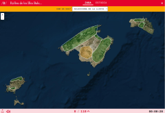
Do you know what is the name of each landform shown on the map? You have to choose the right answer from a list with several possible options.
Zoom in or zoom out the map in order to adjust it to the s ...
Do you know what is the name of each landform shown on the map? You have to choose the right answer from a list with several possible options.
Zoom in or zoom out the map in order to adjust it to the s ...
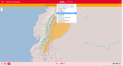
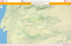
Learn with this interactive game the relief of Ecuador. Choose from the proposed list each element that the map points to.
Enlarge or reduce the map with the zoom and adjust its size to the screen of y ...
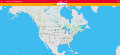
Choose from the proposed list the name of each of the ten largest lakes in the United States indicated on the map.
Zoom in or out of the map and adjust its size to the screen of your device. You can al ...
Would you know to locate on the map each landform you are being asked for? Try yourself with this interactive map of Didactalia.
Zoom in or zoom out the map in order to adjust it to the size of your de ...
Do you know what is the name of each river of the Principality of Asturias shown on the map? Test yourself with this interactive map, you have to choose the right answer from a list of several options ...
Add to Didactalia Arrastra el botón a la barra de marcadores del navegador y comparte tus contenidos preferidos. Más info...


