
Cargando...
Find
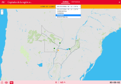
Locate each of the Departments of the southwest region of Uruguay on the map. Drag and drop the pieces of this map in the right place.
On mobile you can zoom in or out of the map and adjust the size to ...
Do you know what is the name of each capitals of the region northeast of Argentina shown on the map? Test yourself with this interactive map, you have to choose the right answer from a list of severa ...
Would you know how to place all the old cities on the map?
Check it out with this fun map of Didactalia, with which you can take a tour of the history of those cities that were built by the most powerf ...
Do you know what is the name of each capitals of the region of Cuyo of Argentina shown on the map? Test yourself with this interactive map, you have to choose the right answer from a list of several ...
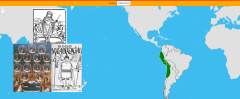
Learn with this interactive game the parts of the Inca Empire.
Zoom in or out of the map and adjust its size to the screen of your device. You can also click on the map and drag it to center it.
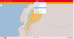
Learn with this interactive game the relief of Ecuador. Choose from the proposed list each element that the map points to.
Enlarge or reduce the map with the zoom and adjust its size to the screen of y ...
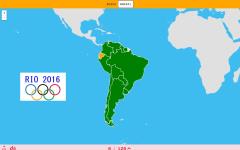
¿Sabrías detallar en el mapa el país del que procede cada uno de los deportistas olímpicos por los que te cuestiona el juego? Los deportistas están en la siguiente ...
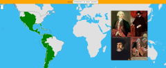
Place on this map the viceroyalties belonging to Spanish America around 1800.
This map is inspired by the Milenioscuro Map, which you can check here.
Zoom in or out of the map and adjust its size to the ...
Sitúa en este mapa los virreinatos pertenecientes a la América española hacia el año 1800.
Este mapa está inspirado en el de Milenioscuro, que puedes consultar aqu&ia ...
Would you know to locate on the map each landform you are being asked for? Try yourself with this interactive map of Didactalia.
Zoom in or zoom out the map in order to adjust it to the size of your de ...
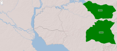
Do you know what is the name of each capitals of the region central-west of Brazil shown on the map? Test yourself with this interactive map, you have to choose the right answer from a list of severa ...

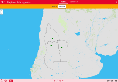
Do you know what is the name of each physical relief of Uruguay shown on the map? Test yourself with this interactive map, you have to choose the right answer from a list of several options.
Zoom in o ...
Add to Didactalia Arrastra el botón a la barra de marcadores del navegador y comparte tus contenidos preferidos. Más info...


