
Cargando...
Encuentra
visualización
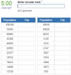
Guess the biggest cities in Mexico according to the 2010 census. Napomena:Nijesu svi podaci o stanovnistvu tacni.Quiz by dragan (subscribe) - Apr 6, 2014
It is an educational content by JetPunk, ...
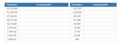
Can you name the most populous nations?
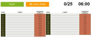
http://www.sporcle.com/games/g/most_populous_capitals
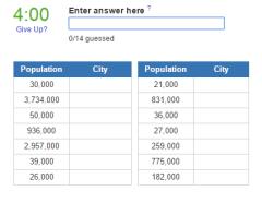
There are 14 US cities, with an urban area population of 20,000 or more, on its land border. The first 4 are adjacent to Canada, the remaining 10 adjoin Mexico. How many can you name?
It is an educatio ...

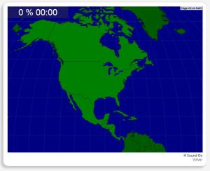
Train je brein met topografie.
Zoek geografische kenmerken zijn: Belize, Canada, Costa Rica, Cuba, Dominicaanse Republiek, El Salvador, Guatemala, Haïti, Honduras, Jamaica, Mexico, Nicaragua, Panama, V ...
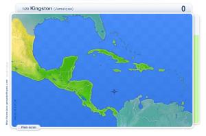
Train je brein met topografie.
Zoek geografische kenmerken zijn: Belmopan, Guatemala-Stad, Havana, Kingston, Managua, Mexico-Stad, Ottawa, Panama, Port au Prince, San José, San Salvador, Santo Domingo, ...
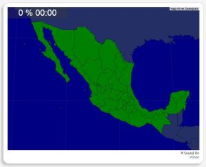
Ydych chi'n gwybod sut i leoli nodweddion daearyddol i gyd yn gywir? Gallwch chi ddangos hyn trwy gwblhau'r map rhyngweithiol gwreiddiol.
Gwledydd o hyd yw: Aguascalientes, Baja California, Baja Califo ...
Vous devez cliquer le plus près possible de la ville demandée. Vos résultats sont calculés en fonction de la distance entre votre clic et l'emplacement exact. Il y a un ...
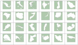
Can you name the countries by their outline?
Name the Countries that have their name in the capital.
It is an educational content by JetPunk, site that contains a wide variety of quizzes.
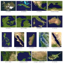
Guess what country or territory is pictured in these satellite images.
It is an educational content by JetPunk, site that contains a wide variety of quizzes.
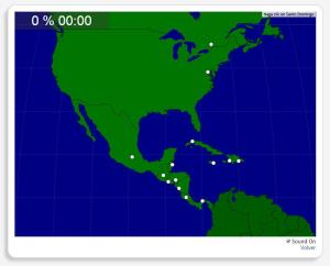
¿Sabes localizar todos los países de América del Norte y Central correctamente? Puedes demostrarlo completando este original mapa interactivo.
Los países a localizar son los siguientes: Belice, Canadá, ...
Añadir a Didactalia Arrastra el botón a la barra de marcadores del navegador y comparte tus contenidos preferidos. Más info...


